


Drone thermal imaging technology has developed rapidly in recent years. It can not only be used to collect information in complex environments, but also assist in search and rescue, industrial inspections, agricultural management and other industries.
However, whether the infrared thermal imaging images of drones can be used for modeling is still a topic worth discussing. Here, let us learn more about drone thermal imaging modeling.
Does drone thermal imaging support two-dimensional and three-dimensional modeling?
The answer is: Yes, but there are certain limitations and application conditions.
The principle of drone thermal imaging modeling
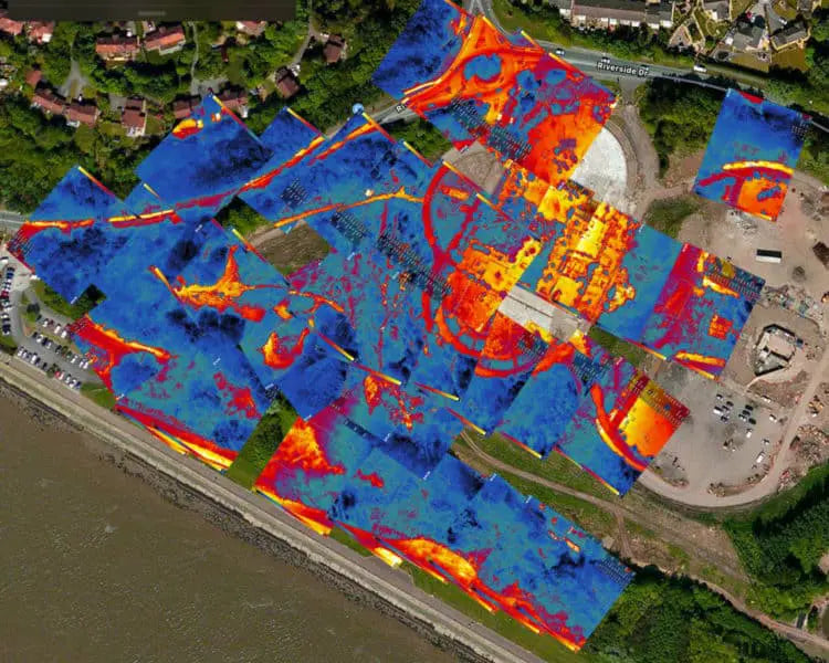
Thermal imaging drones are equipped with infrared cameras to generate images by capturing infrared radiation emitted by objects. Unlike traditional visible light cameras, thermal imaging cameras can detect temperature differences and generate heat maps that represent temperature distribution in colors (such as white in hot mode, hot areas are white and cold areas are black). These images not only contain visual information, but also embed metadata such as temperature data and GPS coordinates, providing rich materials for modeling.

The modeling process usually relies on photogrammetry technology (Photogrammetry), which generates 2D heat maps or 3D thermal models by splicing and processing thermal images and RGB images taken from multiple angles using software. These models can intuitively display temperature distribution and are widely used in fields such as construction, industry, and agriculture.
For drone thermal imaging modeling, a single thermal image can be built in two dimensions, but it only images and does not contain temperature information. The three-dimensional effect is not good and lacks details. 2D modeling generates a flat thermal map, and 3D modeling generates a three-dimensional model.
Limitations of drone thermal imaging modeling
Although drone thermal imaging images can be used for modeling, they are far less clear or accurate than RGB modeling. Drone thermal imaging three-dimensional models are generally reconstructed through structured light or point cloud matching, which is rough and loses details.
Thermal imaging limitations include:
Low resolution: Thermal imagers generally have low resolution (commonly 320×256 or 640×512), resulting in limited details.
Insufficient contrast: Thermal maps mainly rely on temperature differences to form images, lack texture, and SfM reconstruction is difficult.
Distortion and edge blur: Thermal imaging lenses are prone to edge thermal drift, which affects image matching accuracy.
Lack of color feature points: Visible light images rely on color/texture features for registration, while thermal images have few feature points and are not easy to align.
Solutions for thermal imaging modeling
There are many difficulties in thermal imaging modeling, but most thermal drones use dual-light cameras to make up for the problem of insufficient accuracy of thermal imaging images, such as the Autel EVO II Dual 640T V3, which uses an 8K visible light camera and a 640*512@25fps thermal camera.

Therefore, the feasibility and effect of thermal imaging modeling can be improved from the drone's thermal + visible light fusion images, professional software support, and optimized flight routes and shooting conditions:
1. Thermal + visible light fusion (Dual Sensor) modeling
Use a drone equipped with a dual-light lens (such as DJI M3T, Autel EVO II Dual) to collect RGB images and thermal images at the same time.
First use RGB images for modeling, and then map the thermal map to the RGB model to achieve a 3D effect of texture mapping or thermal map visualization.
2. Professional software support
Software such as Pix4Dmapper, Agisoft Metashape, SkyeBrowse, and FLIR Research Studio support infrared image processing and can be combined with RGB images for point cloud modeling or orthophoto production.
Some software supports image registration, which can accurately overlay thermal maps on 3D models.
3. Optimize flight routes and shooting conditions
Maintain a constant altitude, fly smoothly, and increase the overlap rate of thermal images (it is recommended that the front/back/side overlap rate is at least 80%/70%).
Choose to shoot in the morning or evening to increase the temperature difference and improve the contrast of the thermal map.
Summary
UAV thermal imaging can be modeled, but it is more for functional positioning and temperature distribution visualization rather than pursuing exquisite 3D details. The most ideal way is to merge the thermal map with the RGB modeling results to achieve multi-dimensional presentation of spatial + thermal data.
With the improvement of infrared camera resolution and the development of AI point cloud recognition technology, the accuracy and usability of thermal imaging modeling will be further enhanced in the future.
Read More:
What is 3D Mapping Thermal Imaging Drone?


