


GPS Drones: Everything You Need to Know
GPS drones have become a new direction for the advancement of many consumer drones. GPS drones will help drone pilots to better control drones, so who knows GPS drones?
What Is A GPS Drone?
GPS drones are equipped with a GPS module inside the drone, allowing them to know their position relative to a network of orbiting satellites. Connected to the signals of these satellites, the drone can perform functions such as positioning, autonomous flight, return-to-home and waypoint navigation.
How Do GPS Drones Work?
First, the GPS module is used to receive signals. A global network of orbiting satellites transmits signals received by the GPS module via radio receivers. These signals allow the module to determine its position, velocity and time. Access to more signals and systems increases the accuracy of positioning, thereby improving all GPS related functions of the drone.
How Much Is A GPS Drone?
For drone beginners, maybe you just want to learn the fun of drone flying. Toy drones or regular consumer drones? The low cost of toy drones makes it difficult to carry GPS modules. Typically, drones with GPS modules cost upwards of $200.
Autel Robotics offers true quadcopter GPS drones, including consumer drones and enterprise drones, buy a GPS drone from us.

Do I Need A Drone With GPS?
For drone pilots, the need for a drone with GPS depends on your purpose. Most drone pilots will want more after they experience a drone flight. drones with GPS modules can improve the performance of drones and be used in more scenarios.
Flight Stability
Installing GPS on your drone can help the quadcopter fly stably, using GPS can help the drone maintain a high hover, if it finds that it has drifted off its original position, it will automatically correct and return to the mid-air same location.
The same principle applies to the stability of the drone in the wind. In light wind conditions, GPS helps the drone to maintain its course more smoothly and stably by identifying its position.
Altitude Hold
For drone beginners, it can be troublesome to practice the altitude hold of the drone. The drone with GPS can precisely locate the drone, and this altitude limit is preset in the flight control. Autel's novice mode uses this principle, limiting altitude to 30 meters.

RTH
The return-to-home feature is one of the best features for beginner pilots. A drone with RTH will remember and return to its exact take-off position.

If the battery of the drone is too low, the signal from the Autel controller is interrupted, and the connection with the controller is completely lost, you can use the one-key return-to-home function of the GPS drone to bring your drone home.
Browse related articles: What Is An RTH Drone? Do I Need An RTH Drone?
Flight Log Report
Many GPS drones create a flight log of each flight - when it flew, where it flew, etc. This only helps with record keeping, but also helps locate and recover crashed drones. You can access the flight log through the controller or controller app and determine the last known GPS position. Your drone will most likely be there, or not too far away.
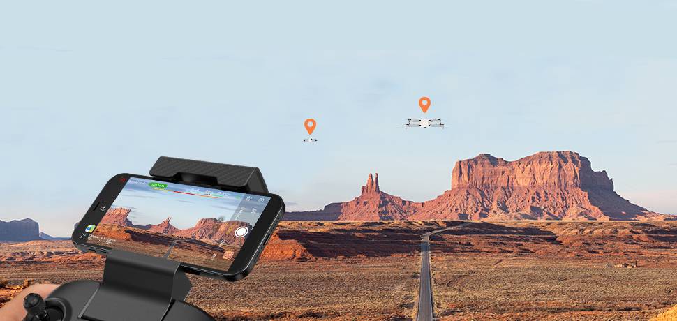
Waypoint Navigation
Many advanced drones can create flight paths that allow the drone to automatically plan flight shots along the route. This is inseparable from the GPS function. Every time the drone creates a waypoint, it is a specific GPS coordinate. The autonomous flight mode of the GPS drone not only allows the drone to accurately travel along the established route, but also can hover and shoot at the waypoint. A great feature for drone photographers.
Waypoint navigation is used in most commercial drones, and many areas require the use of drones with GPS when performing aerial operations. Surveying, inspection, construction, and agriculture all feature drones with GPS.

Mapping Function
When the drone performs surveying, mapping and mapping tasks, the GPS module plays a vital role in marking objects by the drone. When using the 3D mapping function for an object, although RTK/PPK will lock the position of the object more accurately, accurate to 0.1cm, the drone with GPS function will make the positioning of the drone more accurate.
Browse related articles:PPK VS RTK – Which is the Best Mapping Drone Technology?
New Rules For Drones: Drone Remote ID
On April 21, 2021, the U.S. FAA officially introduced new drone Remote ID requirements. Part of compliance with the new law requires all drones to broadcast their GPS coordinates, so by October 2023 all your drones will need GPS!