


Drone surveying is a modern method of acquiring spatial data using unmanned aerial vehicles. The Autel EVO2 Dual 640T RTK V3 accurately maps areas, allowing geological experts to analyze and interpret data more accurately than ever before.
What is drone surveying?
High-precision drones equipped with advanced sensors, cameras, GPS systems and RTK positioning systems (accurate up to 1 cm) can collect data from hard-to-reach places, making them a versatile tool for surveyors.
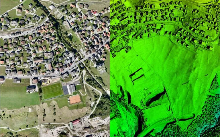
Drone surveying technology enables fast and accurate mapping of areas, which is very valuable in many fields such as construction, agriculture and spatial planning. For land surveyors, surveying with drones can create accurate 3D maps, orthophotos and digital terrain models (DTMs) and is more efficient than traditional surveying methods.

How do drones perform geodetic surveying?
The application of drones in surveying has a wide range of possibilities and is revolutionizing traditional field surveying methods.
First, camera drones are able to collect data quickly and efficiently, greatly reducing project implementation time. Thanks to advanced photogrammetry technology, drones can create detailed orthophotos and 3D models, which are very valuable in terrain analysis.
Thermal imaging drones are also used to inspect difficult-to-access infrastructure such as bridges and power lines. In addition, drones can monitor environmental changes such as soil erosion or changes in forest cover, which is essential for natural resource management.
Finally, drone RTK technology is being used to create accurate cadastral maps, thereby simplifying administrative processes related to land management. These superior features are integrated into the Autel 640T RTK V3 drone, which can accurately and effectively complete geodetic survey tasks.
Surveyor drones: the next generation of work tools
Drones have become a new generation of tools for surveyors, with functions that cannot be achieved by traditional surveying methods. The introduction of surveying drones has greatly shortened surveying time, improved efficiency, reduced labor costs and potential dangers.

Equipped with a high-quality camera and GPS system, the Autel EVO2 Dual 640T RTK V3 drone can accurately measure large areas in a short period of time. Advanced data processing software enables surveyors to create detailed 3D models and orthophotos, which are essential in many engineering and construction projects.
Drones can also be equipped with various types of sensors, such as LiDAR, which can accurately map terrain even in difficult conditions such as dense forests. The 640T RTK drone is equipped with an 8K visible light camera, a 640*512 infrared imaging camera, and the combination with RTK technology further improves the accuracy of the measurement, making it an irreplaceable tool in geodetic surveying.
Learn about drone photogrammetry technology
Photogrammetry is a key technology for accurate terrain mapping using drones.
It involves creating an accurate spatial model based on aerial photos taken from different angles. Thanks to advanced computer algorithms, these photos can be converted into a three-dimensional terrain model that reflects its actual shape and contours.
Drone photogrammetry can also create scaled and geographically relevant orthophotos, which makes them very useful in geodetic surveying and cartographic analysis. This process requires precise drone flight planning and the use of high-quality photography equipment and data analysis software.

With photogrammetry technology, surveyors can obtain the detailed and accurate data needed to implement complex engineering projects.
UAV Mapping: Process and Technology
UAV mapping is a process that involves several key steps to ensure high quality and accuracy of the data. Both the Autel EVO II V3 series and the Autel EVO MAX series support mission planning, and the Autel Mapper APP can be used to generate 2D/3D map models.
The first step is mission planning, which involves determining the area to be mapped and planning the flight path of the drone. The drone then flies and collects photos and sensor data of the designated area.
The collected data is then processed using specialized software to combine the photos into a coherent orthophoto map or 3D model.
The process also includes geometric and radiometric corrections to ensure high accuracy and quality of the final product.
Ultimately, the completed maps and models are analyzed and interpreted by surveyors, who can use them for a variety of applications ranging from spatial planning to natural resource management.
UAV Mapping: Digital Terrain Models and 3D Maps
Digital Terrain Models (DTMs) and 3D maps are one of the most important outcomes of terrain mapping using drones.
A DTM is a digital representation of a terrain surface, reflecting its elevation and shape. Using drones to create a DTM allows for detailed and precise data that is essential in many fields such as civil engineering, spatial planning, and natural resource management. 3D maps created based on DTMs allow for three-dimensional visualization of terrain, which is very useful in topographic and design analysis.

Drone technology enables surveyors to obtain accurate and up-to-date data, which allows for more efficient project planning and execution. Digital terrain models and 3D maps are also very valuable for monitoring environmental changes and analyzing the impact of human activities on the environment.
Advantages and Benefits of Using Drones for Surveying
One of the biggest advantages of using drones for surveying is the huge amount of time it saves.
Traditional methods of field surveying are time-consuming and labor-intensive. Drones greatly speed up the surveying process due to their ability to quickly collect data from large areas.
Just a few flights are enough to obtain detailed and accurate data that previously would have required days or even weeks of work.
Due to this, surveying projects can be completed faster and more efficiently, saving time and costs. Drones can also continuously monitor the progress of the work, allowing for quick responses to any issues and necessary corrective actions.

Drone Accuracy: Precise Measurements
The accuracy of drone measurements is one of the key factors that makes them an irreplaceable tool in this field. Drones equipped with advanced GPS systems and sensors such as LiDAR can obtain data with millimeter accuracy.
Thanks to RTK (Real Time Kinematic) technology, drones can achieve higher accuracy, which is essential in many surveying applications. Precise measurements can create accurate maps and terrain models, which are essential for engineering, construction and planning projects. Drone accuracy also means higher data quality, which enables more precise analysis and better design decisions.
Drones Access Hard-to-Reach Places
Drones are the perfect solution to the problem of mapping hard-to-reach places.
Traditional surveying methods often encounter difficulties in areas with complex terrain such as mountains, forests or swamps.
Drones have the ability to fly high and maneuver in hard-to-reach places, so data can be collected from these areas without direct access. This allows areas that were previously difficult to measure to be mapped accurately.
Drones are also equipped with various types of sensors and can operate in difficult conditions such as dense forests or poor visibility. This allows surveyors to obtain data from locations that would otherwise be impossible to reach or time-consuming and laborious.
Autel EVO2 Dual 640T RTK V3 UAV Application in Surveying
Autel EVO2 Dual 640T RTK V3 is equipped with an 8K 0.8-inch sensor and a 640*512@30fps thermal imager. It can support RTK module loads and can implement multiple measurement methods such as RTK, PPK, and Network RTK, with an accuracy of centimeters.
The Autel 640T RTK V3 UAV is revolutionizing precision surveying, providing accuracy that is difficult to match with traditional methods. The compact design of the Autel 640T RTK V3 UAV makes it easy to transport and is ideal for high-speed surveying tasks. Equipped with an RTK system, it provides centimeter-level accuracy, which is very useful for creating accurate maps and terrain models.
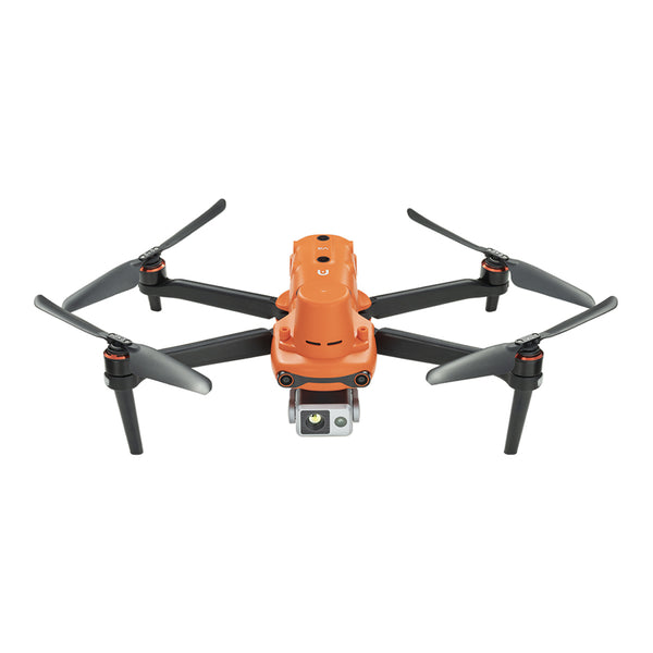
Autel Robotics EVO II Dual 640T RTK V3 Thermal Drone Rugged Bundle
$5799.00 USD
Planning and Implementation of UAV Surveying Projects
Planning UAV Surveying Flights: The Key to Success
Planning UAV flights in surveying is a key factor in the success of any surveying project. The process begins with a precise definition of the mission’s purpose and scope so that appropriate adjustments can be made to the flight path and drone settings.
- Selecting appropriate start and end points as well as determining the flight altitude and speed are essential to obtaining high-quality data.
- It is also important to consider weather conditions and potential terrain obstacles that may affect the safety and accuracy of the measurement.
- Survey drones often use mission planning software that can automatically generate the best flight path and ensure that technical requirements are met.
- Accurate planning of drone flights is essential to obtaining accurate and consistent data, which is critical to the success of any surveying project.
Survey Progress Monitoring with Survey Drones
Monitoring the progress of surveying work is essential to ensure that schedule and design specifications are adhered to.
Drones play a vital role in this process, being able to monitor the progress of work regularly and accurately. With their ability to quickly collect and process data, drones can provide up-to-date information on the progress of the work, allowing potential problems to be identified and necessary corrections to be made.
Photos and 3D models taken by drones can be used to compare the actual status with the design plan, helping to detect deviations and assess the quality of the work performed. Drone monitoring is also more efficient and time-efficient than traditional methods, saving time and costs.
With drones, surveyors can better control the progress of work and ensure high quality of the implemented projects.
Read More: Land Surveying Drone Solutions
Summary
In summary, drone surveying is a modern tool that is revolutionizing the way field data is collected. Thanks to advanced technology, the Autel EVO2 Dual 640T RTK V3 drone is able to map areas quickly, accurately, and efficiently, bringing numerous benefits to many fields.


