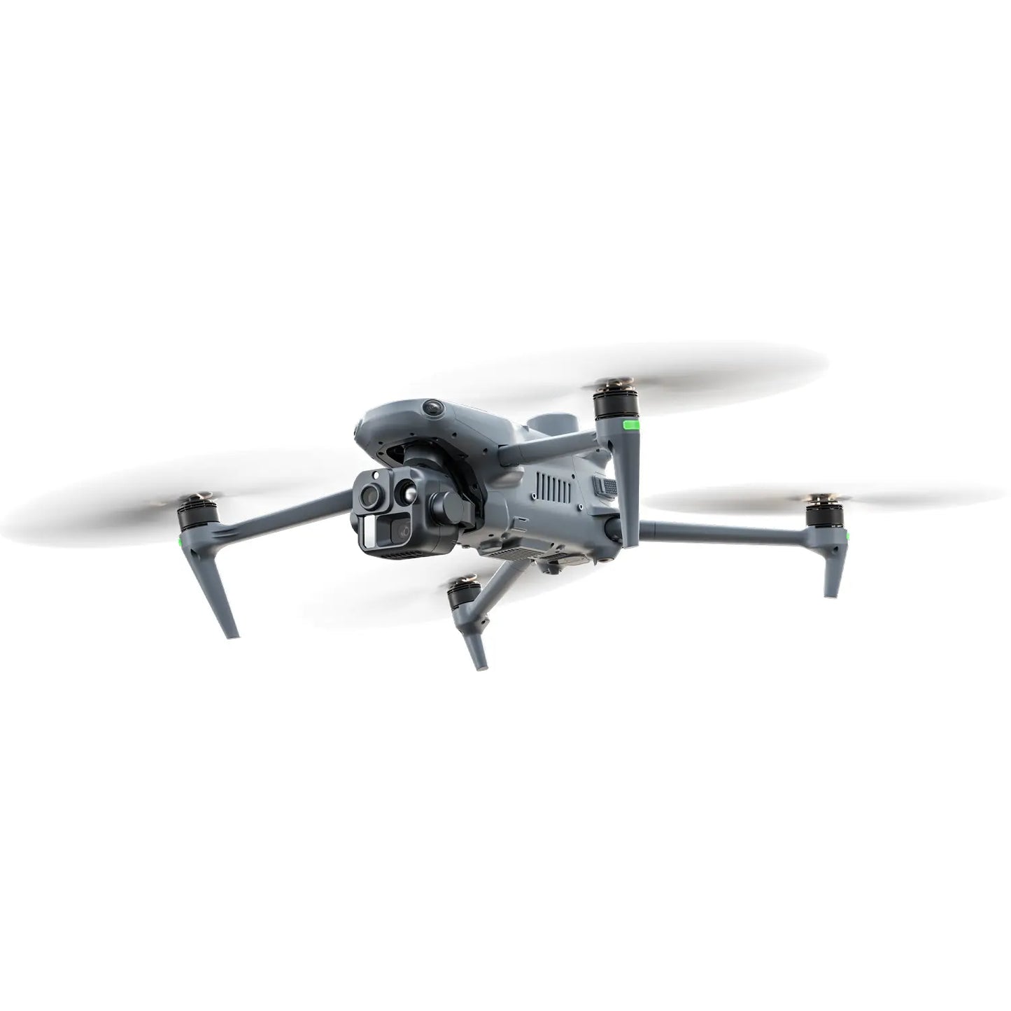
1/8
Skip to product information
1 of 8

Autel Robotics EVO III Series

Autel Robotics EVO III Series

Regular price $0.00
Sale price $0.00 Regular price
Only 0 left in stock - order soon
  • AI-Powered Autonomous Operations
  • Multiple Professional Gimbal Payload Options
  • Up to 50 MP High-Resolution Imaging
  • Up to 176× Hybrid Zoom
  • 640 × 512 Thermal Imaging
  • Up to 2,000 m Laser Rangefinding
  • 720° Omnidirectional Obstacle Avoidance
  • Up to 35 km Autel OmniLink Transmission
  • Advanced Anti-Interference Technology
  • Up to 50-Min Flight Time
  • Multi-UAV & UGV Collaboration
  • Smart Remote Control V3 & AGX Station Support

Payload
Package
Quantity
Quantity

Fast Delivery: Mon, Sep 21 – Wed, Sep 23

Free Shipping from USA

  • American Express
  • Diners Club
  • Discover
  • JCB
  • Maestro
  • Mastercard
  • PayPal
  • Union Pay
  • Visa
  • Free Shipping
  • 30-Days Money Back
  • 1 Year Warranty
  • Lifetime Support
View full details
  • Overview
  • Specification
  • Package
  • Downloads
  • Faqs
  • Autel EVO III Series - Intelligence, Elevated.

    The Autel EVO III Series is Autel Robotics' next-generation enterprise drone platform, bringing AI-powered flight intelligence, autonomous mission execution, advanced sensing, and professional aerial imaging into one integrated system. Also searched as Autel EVO 3, the Autel Robotics EVO III platform is engineered for demanding commercial, industrial, and public-safety operations where reliability, situational awareness, and intelligent automation matter.

    At the center of the series, the Autel EVO III 4T Pro combines professional multi-sensor imaging with thermal imaging, long-range observation, intelligent flight capabilities, and autonomous mission tools. From search and rescue and emergency response to infrastructure inspection, security, and industrial operations, EVO III provides professionals with a smarter and more capable aerial platform for complex missions.

    Autel EVO III AI-Powered Operations

    AI-Powered Operations

    Intelligent Mission Execution
    Autel EVO III Multimodal Interaction

    Multimodal Interaction

    Voice & Text Commands
    Autel EVO III Autonomous Operations

    Autonomous Operations

    Automated Mission Workflows
    Autel EVO III Autel OmniLink

    Autel OmniLink

    Enterprise Connectivity
    Autel EVO III Anti-Interference

    Strong Anti-Interference

    Reliable Mission Connection
    Autel EVO III Omnidirectional Obstacle Avoidance

    Omnidirectional Sensing

    Vision + mmWave Radar + ToF
    Autel EVO III Long Range Transmission

    Up to 35 km Transmission

    FCC, Open Environment*
    Autel EVO III Multi-Payload Platform

    Multi-Payload Platform

    Built for Multiple Missions
    autel EVO III Series

    MULTI-MISSION PAYLOADS

    Choose the Right EVO III for Your Mission

    The EVO III Series offers three mission-focused payload configurations for high-resolution optical inspection, multi-sensor thermal operations and advanced night missions.

    Autel EVO III Fusion 3M Pro Payload

    EVO III

    Fusion 3M Pro

    High-Resolution Optical Imaging

    Built for missions where visible-light detail is the priority. Fusion 3M Pro combines high-resolution imaging, long-range optical observation and LED illumination for routine inspection and daytime enterprise operations.

    50 MP Wide-Angle Camera
    10× Optical Zoom
    6 m LED Fill Light

    Visual inspection, infrastructure inspection, mapping support and general enterprise operations.

    Autel EVO III Fusion 4T Pro Multi-Sensor Payload

    EVO III

    Fusion 4T Pro

    Visible + Zoom + Thermal + Laser

    A versatile multi-sensor payload combining high-resolution visible imaging, long-range optical zoom, thermal imaging and laser rangefinding for missions that require multiple sources of information from a single flight.

    50 MP Wide-Angle Camera
    3.4–11× Optical Zoom
    176× Hybrid Zoom
    640 × 512 Thermal Imaging
    1280 × 1024 Thermal Super Resolution
    5–1,200 m Laser Rangefinder

    Search and rescue, firefighting, public safety, utility inspection, industrial inspection and thermal condition assessment.

    Autel EVO III Fusion 4N Pro Night Vision Payload

    EVO III

    Fusion 4N Pro

    Night Vision + Thermal Intelligence

    Purpose-built for operations after daylight, Fusion 4N Pro combines dedicated low-light and telephoto night-vision cameras with thermal imaging and laser rangefinding for improved situational awareness in dark environments.

    2.3 MP Low-Light Night Vision
    8 MP Telephoto Night Vision
    ISO 100000 Tele Night Vision
    640 × 512 Thermal Imaging
    1280 × 1024 Thermal Super Resolution
    5–1,200 m Laser Rangefinder

    Night patrol, perimeter security, law enforcement, nighttime search operations and low-light surveillance.

    Enterprise Flight Performance

    Autel EVO III - Built for Longer, More Demanding Missions

    The Autel EVO III Series is engineered for demanding enterprise operations with long-range video transmission, extended flight endurance and high-speed performance. Designed to cover larger areas with greater efficiency, the Autel Robotics EVO III provides the range, reliability and mobility required for inspection, search and rescue, public safety, mapping and other professional drone missions.

    35 km Max Video Transmission Distance

    Long-range video transmission provides reliable mission visibility across large operational areas.

    35 km under FCC standards when used with the AGX Station. Maximum transmission distance with Smart Remote Controller V3 is 25 km under FCC standards.
    Up to 48 min Max Flight Time ABE41: 48 min · ABE40: 38.5 min
    23 m/s Max Horizontal Speed Forward · Ludicrous Mode · No Load
    IP43 Protection Rating Built for demanding field operations
    5,000 m Max Service Ceiling Above sea level*
    -20°C to 50°C Operating Temperature Designed for varied environments
    ≤8 sec Quick Battery Swap Complete the battery swap within 8 seconds
    ±0.1 m RTK FIX Positioning Horizontal & vertical positioning accuracy

    * Video transmission performance varies by region, controller and operating environment. Maximum stated transmission distance: FCC — 35 km with AGX Station / 25 km with Smart Remote Controller V3; CE — 15 km; SRRC — 15 km; MIC — 15 km. Actual performance may vary due to interference, obstacles, local regulations and environmental conditions. The 5,000 m maximum service ceiling is based on current product specification information and should be confirmed against the final production specification before publication.

    Advanced Flight Safety

    Autel EVO III 720° Omnidirectional Obstacle Avoidance

    The Autel EVO III Series features 720° omnidirectional obstacle avoidance with multi-source perception for comprehensive environmental awareness. Designed for complex enterprise missions, the system helps the Autel Robotics EVO III detect surrounding obstacles and navigate challenging environments with greater safety and confidence during inspection, search and rescue, public safety and other professional drone operations.

    EVO III Series · Omnidirectional Perception System

    720° Omnidirectional Sensing

    Comprehensive environmental perception helps the aircraft detect obstacles around its flight path and respond to changing surroundings.

    Small Object Detection Designed to recognize challenging obstacles such as thin wires during complex flight operations.
    Real-Time Path Planning Dynamically updates the flight path as the aircraft encounters obstacles and changing environments.
    Day & Night Awareness Multi-source perception supports obstacle awareness across challenging lighting and mission conditions.

    AI-Powered Operations

    From Command to Mission.

    Tell EVO III what the mission needs.

    Multimodal interaction allows the system to understand mission requirements, generate flight plans and assist with autonomous mission execution.

    Voice Commands Text Commands
    EVO III AI Mission Demonstration AI Mission Demonstration
    01 Command Define the mission through natural voice or text interaction.
    02 Understand AI interprets mission intent and relevant operational requirements.
    03 Plan Mission routes and execution workflows are generated intelligently.
    04 Execute The aircraft carries out the planned mission with autonomous assistance.

    AI-Powered Perception. Recognition. Planning. Decision-Making. Execution.

    Autel EVO III AI-powered autonomous operations integrate environmental perception, intelligent recognition, mission planning, decision-making and task execution into a streamlined workflow. AI and autonomous capabilities may vary depending on firmware, software configuration, mission type and regional availability. Appropriate operator supervision is required.

    MULTI-DEVICE & MULTI-AIRCRAFT COLLABORATION

    Air-Ground Collaboration

    Powered by Autel OmniLink, the EVO III Series enables coordinated operations across multiple UAVs and compatible ground units, supporting real-time information sharing, rapid deployment and more efficient mission execution.

    One-Tap Takeoff and Return-to-Home for Multiple UAVs
    01

    One-Tap Takeoff/RTH for Multi-UAVs

    A single command enables multiple UAVs to take off or return simultaneously, allowing teams to deploy rapidly and respond more efficiently.

    Autel EVO III Rapid Multi-Unit Deployment
    02

    Rapid Multi-Unit Deployment

    Manage multiple UAVs from a coordinated command environment and rapidly assign aircraft to mission positions for faster and more efficient deployment.

    Multi-Zone Collaborative Operations
    03

    Multi-Zone Collaborative Operations

    Mission zones can be assigned across multiple UAVs, allowing teams to divide patrol, inspection and search tasks more efficiently.

    Multi-UAV Data Sharing
    04

    Multi-UAV Data Sharing

    Synchronize live video and sensor data across multiple UAVs, giving operators and commanders a shared view of the mission environment.

    Professional Control

    Smart Control for Every Mission

    From portable field operations to advanced multi-aircraft command, the EVO III Series offers professional control solutions designed around different mission requirements.

    Autel Smart Remote Control V3

    Autel Smart Remote Control V3

    7.9" High-Brightness Display 2048 × 1536 Resolution
    2000 nits Max Brightness Clearer outdoor visibility
    Up to 4.5 h Continuous Operation Approx. 2 h Full Charge
    128 GB Built-In Storage Convenient footage backup
    HDMI Output Output live video signals to compatible external displays.
    USB Expansion Supports expansion with a compatible 4G module.
    Up to 20 MB/s High-speed footage download from the aircraft to a mobile device.
    Mission Interface Access flight information, live imagery and intelligent mission tools.

    EVO III Control Ecosystem

    From Field Control to Advanced Mission Command

    Choose between portable Smart Remote Control V3 operation and the advanced Autel AGX Station for larger, more complex enterprise missions.

    Standard Field Control

    Smart Remote Control V3

    A portable professional controller designed for everyday EVO III flight and mission operations.

    7.9" High-Brightness Display
    2000 nits Maximum Brightness
    Up to 25 km* Video Transmission
    Up to 4.5 h Continuous Operation
    Advanced Mission Command

    Autel AGX Station

    An advanced ground control platform built for intelligent planning, large-scale operations and multi-aircraft mission management.

    Up to 35 km* Video Transmission
    3D Routes Advanced Mission Planning
    Multi-Aircraft Mission Control
    AI-Powered Task Planning & Workflow

    * Maximum transmission distance depends on regional certification, equipment configuration and operating conditions. Under FCC standards, EVO III supports up to 35 km with Autel AGX Station and up to 25 km with Smart Remote Control V3. Actual performance may vary due to interference, obstacles and local regulations.

    EVO III AUTONOMOUS FLIGHT

    Multi-Environment Autonomy

    EVO III can perform precise navigation, obstacle avoidance, and real-time route planning in complex environments, including day, night, low-light, or no-GNSS conditions. EVO III's payloads can clearly identify subjects and collect evidence even in near-dark conditions.

    24/7 Positioning and Navigation


    Low-light/IR fisheye + visual SLAM

    Precise navigation in night, low-light and GNSS-denied conditions.


    Multi-source fusion navigation

    Deeply integrates GNSS, vision sensors, inertial measurement units, and magnetometer/barometer data to enable complementary strengths and real-time error correction, improving positioning robustness.

    EVO III OMNILINK TRANSMISSION

    Autel OmniLink Video Transmission

    The EVO III Series features the next-generation Autel OmniLink transmission system. It delivers high-bandwidth performance and supports simultaneous multi-channel HD video streaming for clear, detailed, and real-time imagery. The system automatically selects the optimal link and leverages 4G-enhanced transmission for extended coverage and stable connections.

    Multi-Channel Video

    Connect up to 4 video streams from multiple units, allowing operators to monitor different UAVs and other camera angles simultaneously.

    Autel EVO III Multi-Channel Video Transmission
    Autel EVO III 4G-Enhanced Video Transmission

    4G-Enhanced Video Transmission

    Supports a 4G-enhanced transmission module combined with high-gain onboard antennas, ensuring stable connectivity over long distances and in challenging terrain.

    EVO III OPEN DEVELOPMENT

    Autel SDK Ecosystem

    Autel SDK provides an open and flexible development platform with comprehensive support across hardware interfaces, flight control, and intelligent capabilities, enabling developers and partners to build customized solutions for diverse enterprise applications.

    Autel SDK Development Platform
    Autel Mobile SDK and Payload SDK

    Mobile SDK / Payload SDK

    A streamlined software and hardware architecture helps developers get started quickly, simplifying integration and enabling customized UAV applications for a wide range of enterprise workflows.

  • Professional Drone Technical Specifications

    Weight ABE40: 1545 g
    ABE41: TBD Note: Standard weight of the drone includes the gimbal, battery, propellers and microSD card. Product weight may vary due to material batches and other factors. Please refer to the actual product.
    Maximum Take-off Mass (MTOM) EU: 1890 g
    Other areas: 1999 g
    Maximum Additional Load Weight 500 g
    Aircraft Dimensions 649 × 568 × 167 mm (unfolded, incl. propellers)
    276 × 136 × 146 mm (folded, excl. propellers)
    Aircraft Material PA612 + GB + GF
    Diagonal Wheelbase 460 mm
    Propeller Material Nylon + Glass Fiber
    Propeller Length 11 inches, 1136
    Propeller Weight 11 g
    Maximum Propeller Rotational Speed 8500 rpm
    Maximum Ascent Speed Slow: 2.5 m/s
    Smooth: 3 m/s
    Standard: 6 m/s
    Ludicrous: 14 m/s (No Load)
    Maximum Descent Speed Slow: 2.5 m/s
    Smooth: 3 m/s
    Standard: 6 m/s
    Ludicrous: 10 m/s (No Load)
    Maximum Horizontal Flight Speed (Windless Near Sea Level) Slow: 3 m/s
    Smooth: 10 m/s
    Standard: 15 m/s forward & backward, 10 m/s sidewards
    Ludicrous: 23 m/s forward, 20 m/s backward, 20 m/s sidewards
    Maximum Service Ceiling Above Sea Level 5000 m (To be tested)
    Maximum Flight Altitude CN / CE: 120 m
    USA: 400 ft
    Maximum Flight Time (Windless) With ABE40 Battery: 38.5 min
    With ABE41 Battery: 48 min
    Maximum Range With ABE40 Battery: 28 km
    With ABE41 Battery: 33 km
    Maximum Hovering Time (Windless) With ABE40 Battery: 34.5 min
    With ABE41 Battery: 42 min
    Maximum Wind Resistance Horizontal flight: 12 m/s
    Maximum Tilt Angle Slow: 33°
    Smooth: 33°
    Standard: 33°
    Ludicrous: 38° Applies when the drone is more than 10 m above the ground.
    Maximum Angular Velocity Pitch axis: 300°/s
    Heading axis: 120°/s
    Operating Temperature -20°C to 50°C
    IP Protection Rating IP43
    Hot-swappable Batteries Supported Note: Enable the Quick Battery Swap function in the Autel Enterprise App in advance and complete the battery swap within 8 seconds. Quick battery swapping below -10°C may fail.
    Internal Storage 256 GB internal storage, approximately 176 GB available Remaining available space may vary depending on the firmware version.
    Memory Card Type microSD Class 10, UHS-3, V30 or higher
    Maximum capacity: 1 TB
    Strobe Integrated
    GNSS GPS + Galileo + BeiDou + GLONASS
    Hovering Accuracy Vertical:
    ±0.1 m (when visual positioning is working properly)
    ±1.5 m (when GNSS is working properly)
    ±0.1 m (when RTK FIX is activated)

    Horizontal:
    ±0.3 m (when visual positioning is working properly)
    ±1.5 m (when GNSS is working properly)
    ±0.1 m (when RTK FIX is activated)
    Wi-Fi Protocol Supports Wi-Fi 6
    Wi-Fi Operating Frequency 2.4G: 2.400–2.476 GHz*, 2.400–2.4835 GHz
    5.1G: 5.15–5.25 GHz**, 5.17–5.25 GHz***
    5.8G: 5.725–5.829 GHz*, 5.725–5.850 GHz * Only applicable to SRRC regions.
    ** Only applicable to FCC, CE (excluding Germany) and UKCA regions.
    *** Only applicable to Germany.
    Some frequencies are only available in certain regions or for indoor use. Please follow local laws and regulations.
    Wi-Fi Effective Isotropic Radiated Power (EIRP) 2.4G: ≤30 dBm (FCC); ≤20 dBm (CE/SRRC/UKCA)
    5.2G: ≤30 dBm (FCC); ≤23 dBm (CE/UKCA)
    5.8G: ≤30 dBm (FCC/SRRC); ≤14 dBm (CE/UKCA)
    Camera Type XL902 / XL903
    Weight 215 g
    Mechanical Range Pitch: ±65°
    Roll: ±55°
    Yaw: -140° to 105°
    Controllable Range Pitch: -90° to 60°
    Stability System 3-axis mechanical gimbal (pitch, roll, yaw)
    Max Control Speed (Pitch) 100°/s
    Angular Vibration Range <0.005°
    Zoom Camera
    Image Sensor 1/2" CMOS
    Effective Pixels: 50 MP
    Lens DFOV: 29.6°–9.3°
    35 mm Equivalent Focal Length: 80–264 mm
    Aperture: f/2.8–f/4.5
    AF Type: PDAF + CDAF
    Manual Focusing Distance: 2 m to Infinity
    ISO Range Auto: ISO 100–6400
    Manual: ISO 100–6400
    Shutter Speed Photo: 8 s–1/10000 s
    Video: 1/30 s–1/10000 s
    Zoom 176× Hybrid Zoom
    3.4–11× Optical Zoom
    Max Photo Resolution 50 MP: 8192 × 6144
    Photo Format JPEG
    Video Resolution 4K: 4000 × 3000 @ 30 fps, 60 Mbps
    1080P: 1440 × 1080 @ 30 fps, 20 Mbps
    Video Subtitles Subtitle Enable Switch: Default Off
    Subtitle Form: Subtitle track embedded in video
    Subtitle Information: GPS, GPS Home / Current Date and Time / ISO / SHUTTER / EV / F-NUM
    Video Encoding H.264 / H.265
    Video Format MP4
    Wide Angle Camera
    Image Sensor 1/0.98" CMOS
    Effective Pixels: 50 MP
    Lens DFOV: 85°
    35 mm Equivalent Focal Length: 23 mm
    Aperture: f/1.85
    Focus Range: 1 m to Infinity
    ISO Range Auto Mode: ISO 100–51200
    Manual Mode: ISO 100–6400
    Zoom 3.3× Digital Zoom
    Shutter Speed Photography: 1 s–1/10000 s
    Video Recording: 1/30 s–1/10000 s
    Photo Size 50 MP: 8192 × 6144
    Photo Format JPEG
    Video Resolution 4K: 4000 × 3000 @ 30 fps, 60 Mbps
    1080P: 1440 × 1080 @ 30 fps, 20 Mbps
    Video Subtitles Subtitle Enable Switch: Default Off
    Subtitle Form: Subtitle track embedded in video
    Subtitle Information: GPS, GPS Home / Current Date and Time / ISO / SHUTTER / EV / F-NUM
    Video Encoding H.264 / H.265
    Video Format MP4
    Infrared Thermal Imaging Camera
    Image Sensor Uncooled VOx Microbolometer
    Lens Focal Length: 13 mm
    DFOV: 42°
    35 mm Equivalent Focal Length: 57 mm
    Aperture: f/1.0
    Focus Range: 7 m to Infinity
    Sensitivity (NETD) ≤25 mK @ 25°C, F#1.0
    Pixel Pitch 12 μm
    Wavelength 8–14 μm
    Radiometric Measurement Method Center Measurement
    Point Measurement
    Rectangular Measurement
    Radiometric Temperature Range -20°C to 150°C (High Gain Mode)
    0°C to 550°C (Low Gain Mode)
    Radiometric Measurement Accuracy ±2°C or ±2% of the reading, whichever is greater Applicable when ambient temperature ranges from -20°C to 60°C.
    Accurate Temperature Measurement Distance 5 m
    Digital Zoom 16× Digital Zoom
    Supports Linked Zoom
    Temperature Alert High and low temperature alarm thresholds, with coordinate and temperature value reporting
    Palette White Hot / Black Hot / Iron Red / Rainbow 1 / Rainbow 2 / Lava / Arctic / Hot Iron / Medical / Red Tracing
    Photo Size 640 × 512
    Photo Format R-JPG Images contain temperature information and can be parsed using dedicated SDK and PC tools.
    Video Resolution Normal Mode: 640 × 512 @ 30 fps
    Super Resolution Mode: 1280 × 1024 @ 30 fps
    Video Format MP4
    Laser Rangefinder
    Wavelength 905 nm
    Eye Safety Level Class 1
    Measurement Accuracy ± (1 m + D × 0.15%) D is the distance to a vertical reflecting plane.
    Measuring Range 5–1200 m
    Operating Frequency 900M: 902–928 MHz*
    1.4G: 1.430–1.444 GHz**
    2.4G: 2.400–2.476 GHz, 2.400–2.4835 GHz*
    5.2G: 5.15–5.25 GHz*, 5.17–5.25 GHz**
    5.8G: 5.725–5.829 GHz, 5.725–5.850 GHz* * Applicable only in regions covered by FCC and ISED certifications.
    ** Applicable only in regions covered by SRRC certification.
    *** Applicable only in regions covered by FCC, CE (excluding Germany) and UKCA certifications.
    **** Applicable only within Germany.
    Supported frequency bands and their available ranges vary by country or region. Please refer to local laws and regulations.
    Maximum Transmission Distance (Without Interference and Blocking) FCC: 35 km (AGX Station), 25 km (Smart Remote Controller V3)
    CE: 15 km
    SRRC: 15 km
    MIC: 15 km
    Effective Isotropic Radiated Power (EIRP) 900M: ≤30 dBm (FCC/ISED)
    1.4G: ≤35 dBm (SRRC)
    2.4G: ≤30 dBm (FCC/ISED); ≤20 dBm (CE/SRRC/UKCA)
    5.2G: ≤30 dBm (FCC); ≤23 dBm (CE/UKCA)
    5.8G: ≤30 dBm (FCC/ISED/SRRC); ≤14 dBm (CE/UKCA)
    Sensing Range Forward: 0.5–22 m
    Forward Millimeter-Wave Radar: >40 m
    Backward: 0.5–25 m
    Sidewards: 0.5–40 m
    Upward: 0.5–40 m
    Downward: 0.5–35 m
    FOV Forward:
    Horizontal 100°, Vertical 135°

    Forward Millimeter-Wave Radar:
    Horizontal ±20°, Vertical ±20° (For trees)

    Rear:
    Front-rear 120°, Left-right 120°

    Side:
    Horizontal 100°, Vertical 135°

    Bottom:
    Front-rear 120°, Left-right 120°

    Downward ToF Sensor:
    Front-rear ±45°, Left-right ±30°
    Effective Obstacle Avoidance Speed Forward: ≤15 m/s

    Forward Millimeter-Wave Radar:
    20 m/s for highly reflective obstacles such as trees and buildings
    20 m/s for 2 cm power lines within ±10° range and at a height of >5 m

    Rear: ≤6 m/s
    Side: ≤10 m/s
    Downward: ≤6 m/s
    Operating Environment Forward, backward, sidewards and upward:
    Rich texture on the surface and sufficient lighting conditions.

    Downward:
    Rich texture on the ground, sufficient lighting conditions, and a diffuse reflective surface with reflectivity greater than 20%, such as walls, trees and people. Note: Sufficient lighting conditions refer to illuminance not lower than that of nighttime urban lighting scenarios.
    Autel Smart Controller V3
    Remote Controller RC8.3
    Body Material ABS + PC + TPE
    Dimensions 277 × 188 × 66 mm
    Weight 1750 g
    Operating Temperature -20°C to 50°C
    Storage Temperature 15°C–25°C: within one year
    0°C–30°C: within three months
    -20°C–45°C: within one month
    Protection Rating IP54 Note: Long-term use may lead to protection failure due to aging and wear.
    Operating System Android 15
    Storage Space Built-in Capacity: 256 GB
    Remaining Available Space: Approximately 176 GB Remaining available space may change due to firmware upgrades.
    HDMI Supports 1080P @ 60 fps
    USB-C Charging: Supports PD 100W Fast Charging
    Data: USB 3.1 Gen 2
    Display: Supports DisplayPort v1.4 Display Output
    USB-A Power Supply: 5 V DC, 1 A
    Data: USB 3.0
    GNSS GPS + Galileo + BDS + GLONASS
    Supports L1 + L5 Dual-Frequency
    Wi-Fi Protocol Supports Wi-Fi 6
    Wi-Fi Operating Frequency 2.4G: 2.400–2.476 GHz*, 2.400–2.4835 GHz
    5.2G: 5.15–5.25 GHz
    5.8G: 5.725–5.829 GHz*, 5.725–5.850 GHz * Applicable only in areas covered by SRRC certification.
    The 5.2G and 5.8G bands are not supported in some regions, and the 5.2G band is limited to indoor use in some regions.
    Wi-Fi Effective Isotropic Radiated Power (EIRP) 2.4G: ≤30 dBm (FCC/ISED); ≤20 dBm (CE/SRRC/UKCA)
    5.2G: ≤30 dBm (FCC); ≤23 dBm (CE/UKCA)
    5.8G: ≤30 dBm (FCC/ISED/SRRC); ≤14 dBm (CE/UKCA)
    Bluetooth Bluetooth 6.0
    Bluetooth Operating Frequency 2.400–2.4835 GHz Some regions have designated frequency ranges. Please check local laws and regulations.
    Bluetooth Effective Isotropic Radiated Power (EIRP) ≤20 dBm (CE/SRRC/UKCA)
    ≤30 dBm (FCC/ISED)
    Image Transmission
    Antenna 8 Antennas (4 Transmit, 8 Receive)
    Operating Frequency 900M: 902–928 MHz*
    2.4G: 2.400–2.476 GHz, 2.400–2.4835 GHz*
    5.2G: 5.15–5.25 GHz*, 5.17–5.25 GHz**
    5.8G: 5.725–5.829 GHz, 5.725–5.850 GHz* * Applicable only in areas covered by FCC and ISED certifications.
    ** Applicable only in areas covered by SRRC certification.
    *** Applicable only in areas covered by FCC, CE (excluding Germany) and UKCA certifications.
    **** Applicable only in Germany.
    Supported bands vary by region.
    Effective Isotropic Radiated Power (EIRP) 900M: ≤30 dBm (FCC/ISED)
    2.4G: ≤30 dBm (FCC/ISED); ≤20 dBm (CE/SRRC/UKCA)
    5.2G: ≤30 dBm (FCC); ≤23 dBm (CE/UKCA)
    5.8G: ≤30 dBm (FCC/ISED/SRRC); ≤14 dBm (CE/UKCA)
    Maximum Transmission Distance (Without Interference and Blocking) FCC: 35 km Index used with MDE. Not measured yet; reference index. CE: 15 km
    SRRC: 15 km
    MIC: 15 km Data is based on an open outdoor environment without interference and represents the maximum one-way communication distance without return flight under each standard.
    Display
    Type TFT LCD
    Display Size 8.3 inches
    Maximum Brightness 2000 nits
    Resolution 2266 × 1488
    Refresh Rate 60 Hz
    Touch Control Supports 10-point touch
    Controller Battery
    Battery Type Li-Po 3S
    Rated Capacity 5700 mAh
    Voltage 11.67 V DC
    Battery Energy 66.5 Wh
    Battery Endurance 3.5 hours at maximum brightness
    4.5 hours at 50% brightness
    Battery Replacement Supported
    Smart Battery ABX41-D
    Battery Dimensions Overall Dimensions: 157 × 71 × 47 mm
    Battery Body: 154 × 50 × 44 mm
    Operating Temperature Charging: 10°C–60°C
    Discharging: -20°C–60°C
    Battery Type LiPo 4S
    Rated Capacity 10080 mAh
    Battery Energy 146.88 Wh
    Voltage 13.6 V DC
    Charging Voltage Limit 16.8 V DC
    Rated Charging Power 272 W
    Weight 480 ± 5 g
    Battery Charge Temperature 10°C–60°C
    Battery Storage
    Storage Temperature -20°C to 45°C
    Battery Charger
    Power Input 100–240 V~, 50/60 Hz, 4.5 A Max
    Output Port Battery Interface:
    12–27 V DC, 20 A Max
    Maximum Output: 300 W

    USB-C:
    5 V / 3 A
    9 V / 3 A
    12 V / 3 A
    15 V / 3 A
    20 V / 5 A
    Maximum Output: 100 W
    Total Power Output 300 W
  • What's in the Box

    Autel EVO III 4T Pro Packing List
Delivery
$0.00
Deliver to USA
Deliver to USA

Free Fast Arrival by: -

$0.00
Customer Reviews
0.0 Be the first to review this item
5 ★
0% 
0
4 ★
0% 
0
3 ★
0% 
0
2 ★
0% 
0
1 ★
0% 
0
Write a Review Ask a Question